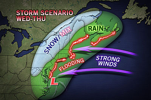
ACCUWEATHER.COM GRAPHIC | Above is a possible scenario for the upcoming storm. Less of the Northeast would be impacted if the storm tracks farther offshore.
If this weekend’s cold temperatures aren’t enough to dampen enthusiasm for the cleanup from Hurricane Sandy, eastern Long Island may experience a nor’easter midweek.
“This storm has the potential to bring strong gusty winds, rain/wintry precipitation and coastal flooding to the tri-state area,” according to a hazardous weather report from the National Weather Service today.
The National Weather Service is advising residents to stay tuned here to determine the exact track the storm will take.
The potential storm is the result of a surface low off the southeast coast of the U.S., which is expected to turn northward and intensify throughout the week.
Night-time temperatures are expected to be in the 30s well into next week.
Weather officials are warning the storm could bring high winds and a surge that could reverse some progress made by LIPA and other work crews in the wake of Hurricane Sandy, though the effects are not expected to be nearly as severe.